Wild West Coast and East Coast of Tasmania, 26th Feb to 16th March 2018
Monday 26th February 2018 Stanley to Woolnorth and return.
After a wild and windy night at the Stanley Caravan Park, the 12 intrepid 4WDrivers set out on their way to Woolnorth. We met our guide Laura at the Woolnorth Tours ($66.00 pp) entry point, climbed into her bus and visited the windfarm and interpretive centre, Cape Grim and the Doughboys and the Woolnorth homestead with the now disused 13 bay sheep shearing shed. Woolnorth is today the biggest dairy farm in Australia.
The Doughboys
At the end of the delightful and informative tour led by Laura and her 12 week old side kick Henry, we headed back to Stanley diverting north along the road to Robbins Island for our secluded lunch in the world’s freshest air, overlooking the shallow waters where Wagu cattle are walked off the island to the market.
Some stopped in Smithton to view the (old) Duck River Butter Factory, Tier Hill Scenic Lookout and Stanley’s heritage streets and wharf.
A dinner at the Stanley pub signalled the official start of our trip for the 7 vehicles and 13 Club members.
Tuesday 27th February Stanley to Marrawah
We all met in “The Nut” chairlift carpark for a walk or chairlift ride to the top where we enjoyed a walk around the track taking in the views out to sea and over Stanley. The wind had still not let up for morning tea at Godfreys Beach where more views of The Nut were enjoyed.
The Nut at Stanley
We passed historic Highfield Estate (the original headquarters for the owners of VDL Company, which managed Woolnorth) on our way to Smithton for fuel and Marrawah for lunch and our overnight camp at very windy Green Point. The afternoon drive to Mount Cameron West known as “Preminghana” by the aboriginal Pirapi people, did not reveal its world renown rock art as it is covered with sand to protect it from weather and vandals. We did drive or walk down to the beach before returning to camp for happy hour.
Wednesday 28th February Marrawah to Sandy Cape
Uncertainty about the Ranger’s Office opening hours allowed us time to visit West Point – the most westerly place in Tasmania – it was raining and the strong westerly wind had not abated. The ranger at Arthur River gave us an update on the track and weather conditions ahead and even though 10 – 15 mm of rain was expected, it was OK to proceed. Our first stop was “Edge of the World” at the mouth of the Arthur River where we enjoyed the great scenery and morning tea. On the ranger’s recommendation we took the beach ‘road’ to Sundown Point – the leader’s first experience of beach driving. It was smooth and hard until we met Sundown Creek where the track went inland. The aboriginal petroglyphs were almost missed as we explored the way across the creek. It was shallow and the track led us to the Nelson Bay fishermen’s shacks, Sarah Anne Rocks, spectacular Couta Rocks and onto Temma for lunch.
The Mouth of the Arthur River
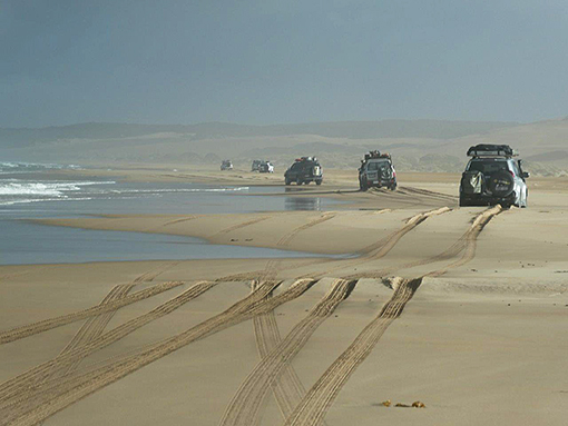
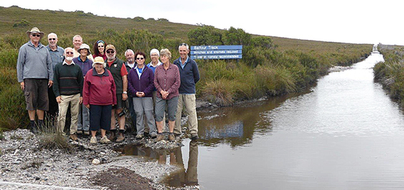
The road became a track as we continued south to Sandy Cape through sand dunes covered with coastal heath. We passed the start of the Balfour Track (something to look forward to on Thursday) and travelled behind the dunes until the track took us onto the beach at Greens Point. The beach run and four river crossings went well with hard sand and none of the threatened quicksand much to our relief – but we still had to return via the same beach! After some searching, a good sheltered campsite with a fire place and toilet was found. Gill, Tineke and Felicity went swimming in the ocean and others for a walk to the beach to see the wind sculptured sand before happy hour around the fire.
On the beach at Sandy Cape
Thursday 1st March Sandy Cape to Corinna
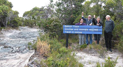
Pinch and a punch for the first of the month! After waking to the dawn chorus, we left Sandy Cape under mostly blue skies. We took the Pedder River track back to the beach to avoid the alternative unused most direct sandy track. The beach had changed considerably overnight but provided no greater challenge than the day before. The next stop was the start of the infamous Balfour Track.
Excited!
After a group photo in case we were never to be seen again, we climbed over rocks larger than Elizabeth Taylor’s engagements rings, across sandy tracks, bog holes and button grass plains. Mark’s car suffered a side wall puncture in one of the watery holes.
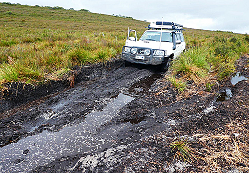
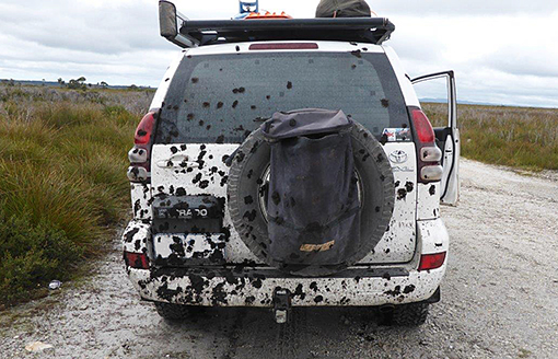
Mud and more mud
On seeing the highway when we were just 743 metres from the end, we encountered the very deep unpassable canal similar to Venice. The leader plunged in not suspecting that the water (thin mud) was so deep – maybe we should look for an alternative way through! Two recoveries were required before we made it to the road to Corinna. Nothing in the literature had indicated that the worst part of the track was so short and so close to the eastern end!
Made it! Relief
To celebrate our achievement, we had lunch at the Balfour Tavern (self-catered)! The Balfour mine has a sad history – it closed down in 1912 after an outbreak of typhoid. The 4 remaining graves were a short walk from the tavern.
The ‘highway’ to Corinna took us to our next campsite where we squeezed in to a bush clearing with permanent tents on site but unoccupied.
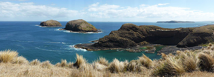
Friday 2nd March Pieman Heads
A most pleasant day was spent on the Pieman River. A relaxed and slow start to the morning with the deadline to be at the 1939 historic boat Arcadia II by 9:45. We were looked after by Captain AJ and deckhand Melissa. AJ pointed out the Huon pine and spoke about the logging history and the other species of hardwoods in the rain forest. Two white bellied sea eagles were spotted. The trip down to the mouth was 1½ hours. There were wonderful reflections on the river which was so clean and it was a beautifully clear and sunny day.
The 1½ hours at the ocean end were spent wandering to the mouth of the Pieman where the waves crashed onto the rocks and we ate the provided lunch perched on the logs washed down in times of flood.
There was a quaint community of shacks to wander past. The trip back went quickly and it was good to see the landscape from a different view point.
On return some went on a 1 hour walk through the rainforest, others slept or sorted out car problems. Tineke and Gill swam across the Pieman and back in the bracing water. We supported the local pub for happy hour, sitting outside in the sunshine. A most pleasant day in the historic setting of Corinna.
Saturday 3rd March Corinna to Trial Harbour
The Pieman ferryman had been persuaded to start an hour early so we assembled at 8 am to more beautiful reflection over the river. The ferryman worked efficiently to get us all over in half an hour, 2 cars at a time.
We made a short detour to Reece Dam with a wonderful view and a passionate explanation of the dam structure by Bill.
Good roads to Granville Harbour was our next stop with panoramic morning tea views over the sea. The township had quite established houses with some comical names. They were obviously proud of their environment and encouraged cleanliness with a sign about littering at the entrance to the town.
We then set off for the Climies track at 10.30. The excitement started 1.5 km later, with the first time a car needed to be pulled out of a bog.
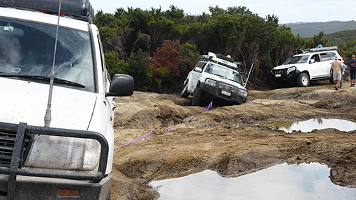
Recovery
Next came a rocky river to crawl across, one boulder at a time and after some road building, each car was guided over. After some more tricky rocky sections we arrived at the dramatic Granite Creek.
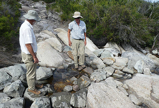
Rocky river crossing
A moving memorial to 3 young people killed while driving on quad bikes reminded us of the treacherous nature of the creek crossing, which has since been bypassed much to our relief. We took a breather there to enjoy the waterfall, ocean view and sunshine. The next bog hole only swallowed one car as the others used the “chicken run” to get through. Another jump down was successfully overcome after some serious assessment. The 19km track only took us 6¼ hours – it was an enjoyable challenge with many technical difficulties to overcome. It was hard to believe that Paul had driven this track (in his Dad’s car) 60 years ago! The only rain we had was whilst we took a photo at the end of the track.
Sadly, the sheltered Little Henty River campsite was taken up by unfriendly campers, so we found an alternative at Goats Rocks. The wind was lazy, but we were happy to pitch our tents after a long day and three tents close together provided an intimate happy hour out of the relentless wind.
Sunday 4th March Trail Harbour to Zeehan
The wind had changed direction and reduced overnight. We returned to the small settlement of Trial Harbour where we visited the History Room containing an interesting display of mining memorabilia and historic photos. The owner – Shirley Smith – also shared quite a bit of information with us.
We then checked out the camp area north of the town and visited the ringing rock – a large boulder that rings when hit with another rock. It also has rings on it worn in by aboriginals. We returned to Little Henty River for morning tea.
On our way to Zeehan, we stopped at the end of the Climies track for a dry group photo and to air up. The afternoon was free and many visited the West Coast Heritage Centre, with its focus on the mining history of the west coast. The caravan park high pressure wash got good use.
Monday 5th March Zeehan to Strahan
A 6:30 start to another beautiful Tassie morning. Then the rain began just as we departed for Montezuma Falls. At the start of the track with the rain still pouring down we re-checked the forecast and decided to drive to The Wall at Derwent Bridge a mere 200 km return out of our way. Wow was that a treat, and amazing 100m of local history carved into 3m high panels of Huon Pine.
We stopped to view the denuded and impressive landscape around Queenstown, largely as a result of the mining activities to extract the copper. Blow Hole lookout provided an excellent viewing platform of the Mt Lyell mine site, and information boards.
Tuesday 6th March Strahan – free day
Beautiful sunny day with heavy morning dew. Most enjoyed the Ocean Beach views and most of us drove along the beach to Macquarie Heads otherwise known as Hells Gates – a misnomer on the day we were there.
Hells Gates at Macquarie Heads
We were all present a Morrisons Sawmill in town where a Huon pine log was sawn into a large plank. The vertical reciprocating originally steam powered saw, now electrical, drew all our 4WD group’s interest. Phil and Paul came away with purchases of Huon pine.
Wednesday 7th March Strahan – Wilderness Railway trip
A short drive took us to the West Coast Wilderness Railway station where the Abt steam train was waiting for us. The Abt train is named after the Swiss inventor who developed the rack and pinion system which enabled the train to climb steep hills. Ash, our carriage hostess, told lots of stories about how the construction gangs lived and worked 118 years ago in the wet rainforest building the track and bridges. The Mt. Lyell Mine General Manager Robert Sticht was very determined to build the railway, with his motto “We find a way or make it”. To him, nothing was impossible. The 4 hour trip went half way to Queenstown, turning around at “Dubbil Barril”. An amazingly sunny warm day in the mid 20’s.
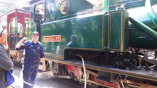
The Abt Loco
In the afternoon we drove north on the hard flat surfaced Ocean Beach to the mouth of the Henty River where Tineke, Gill and Bill tested the button grass stained water. Superb day!
Thursday 8th March Strahan to Quamby Brook
A long day’s drive travelling through beautiful scenery of rolling hills, mountain ranges in the distance and all wrapped in a stunningly clear and sunny day with morning mists rising.
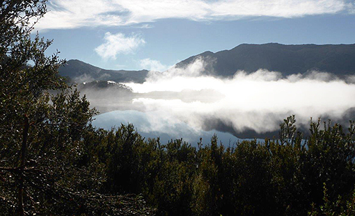
Mist over Lake Plimsoll
We stopped to view Lake Plimsoll to capture the rising mist, passing east of Mts. Read and Murchison on our way to Tullah. Morning tea was very civilised at Lakeside Lodge with scones and waffles and lake views. A short stop to see Wee Georgie Wood the 2-foot gauge train that used to be the only link for Tullah to the outside world.
The dam at Lake Mackintosh was our next brief stop. We chose the only place with views of Cradle Mountain for lunch – the Rocky Mountain Lookout which also gave us good views of the Vale of Belvoir. The road to Mole Creek, where we stopped to purchase leatherwood honey, had some steep sections with views of Mt. Roland along the way. Our campsite at Quamby Brook was a lovely picturesque spot with great camp kitchen and our second opportunity to have a camp fire.
Friday 9th March Quamby Brook to Scamander
Yellow tailed black cockatoos flying and squawking overhead this morning. Headed off on Bogan (!) Road – gravel, travelling through forest and farmland via Bracknell and Cressey, two towns with a reasonable number of good houses. More irrigated farm land. Eventually turned right onto the Midland Highway (roadworks). Shortly after turning onto the Fingal Valley Road we stopped for morning tea by the South Esk River. Mark proceeded to erect his tent to retrieve his phone and Tineke startled a deer. Another stop at the main road to pick some Cox’s Orange Pippin apples. Yum!
At St. Marys we left the bitumen and after a forest ascent we finally had a glimpse of the east coast of Tassie. Soon after lunch we found a plentiful supply of fire wood ready for another fire. Soon after the track required low range as we climbed and descended down to Trout Road, exiting past a ‘Road Closed’ sign! Our campsite was on an arm of the Scamander River. Tineke, Gill, Ruthi and Paul went for a swim in the murky water and others went for a walk. The fire wood was abandoned as fire restrictions were in force, as were the mosquitoes so we retreated to our tents for an early night.
Saturday 10th March Scamander to Blue Tier
We started the day with much merriment for Bill’s birthday and a rendition of ‘Oh what a beautiful morning’. The Skyline Track took us to a lookout which we walked up to get 360° views. Colin and Heather drove up but on advice from the walkers returned the same way as the alternative was going to be a challenge.
Our morning tea stop was at Diana’s Basin, a picturesque spot by the sea. A quick shopping stop at St Helens before setting off for the Blue Tier area. The remains of Moon Mine (tin) was explored before returning to the main car park for lunch. While chatting to another 4WDriver we learnt that our planned camping spot at Pyengana had been taken over by a large group celebrating the birthday of the daughter of the ‘Pub in the Paddock’ owner. Our booking for a meal there was cancelled without us being advised, so we set up camp right where we were.
A short excursion to the old wooden Crystal Creek Bridge had us bushed as the path to it was hard to find. When we returned Phil decide to investigate a squeaky wheel and discovered a brake pad without a pad. It was a long weekend but they decided to return to Devonport in the hope of repairs, or an early return to Melbourne.
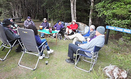
On our short walk through Goblin’s Forest we came across a tiger snake resting on the lichen covered forest floor.
Happy hour at Blue Tier camp
Sunday 11th March Blue Tier to Weldborough (Maa Mon Chin campsite)
We broke camp at Blue Tier and headed south for Pyengana. Phil and Gill had already left to seek a solution to their brake problem. We drove past the Pyengana Reserve and the Pub in the Paddock but couldn’t see any sign of the previous evenings festivities. Our first stop was St. Columba Falls. They were quite spectacular and we had good views from the car park as well as from the viewing platform a short walk away. Ralph Falls were a longer walk to view the long thin drop of water from the top. Both are 90m high.
The Ruby Flats track from Ringarooma to Branxholm was the most overgrown track we came across and we came out with our roof racks decorated with foliage.
After lunch at Derby we took the back tracks to Cascade Dam which had a tragic history. In 1929 the dam wall failed and 3400 million litres of water and a hundred tonnes of rocks and trees came through Derby destroying all before it and killing 14 people. Today it is used for irrigation. Many stark dead trees stood in the water. We continued our dam tour by visiting the concrete buttressed Mt. Paris Dam. Now disused, it has holes cut in it to allow the Cascade River to flow through.
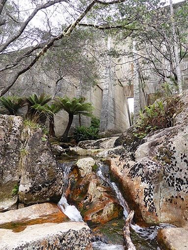
Mt Paris Dam no longer holds back the Cascade River
We were fortunate to have the Maa Mon Chin camping area to ourselves among the trees by the lake.
Monday 12th March Weldborough to Mt. William NP
At Moorina we turned off the Tasman Highway onto Frome Road which took us to Frome Dam, which until recently was used to run a power station. Several tracks were explored until we found the Garibaldi track to Pioneer. We passed the site of the Garibaldi township but it was totally overgrown.
Morning tea was by the Pioneer manmade lake as a result of alluvial tin mining activities. The spoil was used as a local 4WD playground and the lake for water skiing!
Gladstone was the next distraction as Tineke reminisced about time spent here in her youth. The road soon turned to gravel (and dust) as we travelled to the most eastern part of Tasmania – Eddystone Point. A good place to stop for lunch and explore the coastline, lighthouse and surrounding buildings, all closed for maintenance. On return we did a small detour to Ansons Bay, a pretty fishing village.
Stumpy Bay campground in Mt. William NP with its scattered she oaks was a good place to stay for a couple of days.
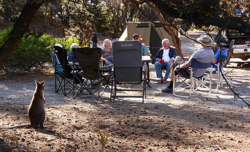
"Excuse me..."
Tuesday 13th March Mt. William NP – free day
Various activities ranged from a walk to Mt. William, visit to Musselroe Bay for a swim and walk around the headland or driving to St. Helens for a shower and laundry. In the meantime, we heard that Phil and Gill’s brakes were fixed and they would be re-joining us soon. Our evening was spent star gazing, satellite watching, eating chocolate, port drinking, and speculaas biscuit eating!
Wednesday 14th Mt William NP to Waterhouse Point
We retraced our tracks back to Gladstone for short a stop at the General Store before continuing on to the Blue Lake. It was struggling under the grey skies to show its true blueness resulting from chemicals used in tin mining. Then back to Pioneer to follow the Old Port Road north. Power lines from the Cape Portland wind farm followed this track so we stopped to ‘hug a pole’ and discuss all things related to the overhead power lines!
We turned off to visit Tomahawk – ‘Tasmania’s best kept secret’, a very picturesque little bay lined with holiday shacks.
Big Waterhouse Lake was our lunch stop where we enjoyed the swans and musk ducks on the lake. We took a turn to South Croppies Point with its soldier crab sand creations. We set up camp at Village Green campsite and after dinner we all huddled out of the wind between the trees and Phil and Gill’s tent.
Thursday 15th March Waterhouse Point to Bellingham
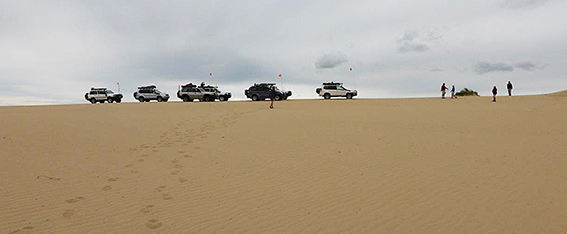
Our first stop was Blackmans Lagoon still within Waterhouse Point, but there was not much to see there. At Bridport we had a short stop for fuel and supplies, before making our way to East Sandy Point. It was time to air down and put our sand flags up, have a cuppa and watch the tide go out.
The sand was reasonably firm as we climbed over the first lot of sand dunes – only one recovery required. The track was fairly easy to follow as it wound through the vegetated dunes. The last section onto St. Albans Bay proved to be a challenge with 4 cars having to have another try or 2 to get over the top. Tyre pressures down to 16 psi and plenty of momentum did the trick, but we won’t mention the 4 tries Phil had to get over the top.
Desert Caravan to West Sandy Point
Lunch at the western end of St. Albans Bay before tackling the next set of dunes. They look more difficult but once we worked out the route – there were no visible tracks – it was an easy 8.5km drive to Little Pipers River. Shortly after the easy river crossing we were soon airing up to find a campsite. Some local help was needed as the previously designated camping area was no longer usable. We ended up on the side of a hill above Bellingham in a she oak grove.
Friday 16th March Bellingham to Devonport
Everyone enjoyed a dry tent to start the day. The kookaburras had a good laugh about the de-commissioning of the thunder-box. Mark and Felicity left the convoy bound for Hobart.
We continued to Low Head to view the 1888 lighthouse and the 1929 foghorn. The compressor for the foghorn air supply has 1200 hours up out of the 500,000 hours design life! Low Head was a significant shipping location in the early days and a large neat pilot’s station is a feature of the settlement.
We crossed the Batman Bridge and travelled into Beaconsfield for a short stop at the site of the 2006 gold mine collapse – now a museum. It was also the first test site in Australia for the fluoridation of drinking water in 1953.
Our last lunch stop was at Bakers Beach in Narawntapu NP before our final run through farm land into Devonport. We scattered to our various accommodation locations before our final dinner at the Drift Café.
The trip was declared a successful one, with amazing weather particularly welcome on the Wild West Coast. The only day we had some rain was the day we planned to go to Montezuma Falls. We heard a few days later that nobody could get through, not even motorbikes, as the track was impassable because of the mud. The people who tried it met another group backing out, because the old railway was too narrow to turn around on.
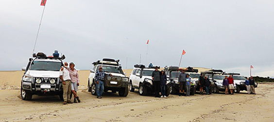
Convoy pic at St Albans Bay
19 days and 2230 km Devonport to Devonport.
Paul and Tineke would like to thank Bill and Gill, Phil and Gill, Wayne and Ruthi, Mark and Felicity, Peter and Colin and Heather for their support and encouragement as well as understanding, as we visited places which held wonderful memories for us as we grew up in Tasmania.